
Description
Vico is a French speaking municipality located in the Department of the southern Corsica (Corse-du-Sud) and the territorial community of Corsica.
Built off the Western coast of the island and the Gulf of Sagone, near the gorges of the Liamone, the small town of Vico tightens its granite on the hillside, at the foot of the first escarpments of the Monte Rotondo massif. It is historically the capital of microrégion of Deux-Sorru .
The Religious and political center of the Western façade of the island at the end of the middle ages, Vico was an active resistance to the Corsicans against the Republic of Genoa, under the impulse of Giovan Paolo di Leca in the 15th century and then of Pascal Paoli in the 18th century. After the annexation and the conquest of Corsica by the Kingdom of France in the year 1769, the city acquired the status of sub-prefecture of the Department of the Liamone (current Southern Corsica “Corse-du-Sud”) between the year 1793 and 1811. Hit hard during the twentieth century by the rural exodus in favor of Ajaccio, Vico remains the tutelary city of a wide mountainous area difficult to access and sparsely populated, extending from Girolata to Calcatoggio.
Situation
Vico is one of the eleven municipalities of the canton of Deux-Sorru , which it is the capital. The sub-prefecture old city, Vico is located on the Western façade of Corsica, about 50 kilometers north of Ajaccio. The Monte Rotondo massif separates the area of Vico of Corte, which is about 30 km in distance. The town is partially adjacent to the regional natural park of Corsica to which it has not adhere. Its current territory was located in the ancient pieve of sorrow in Gio
The only city in the region, Vico is located in the heart of the largest concentration of vilagers in this part of the island, the hamlets and villages of Nesa, Appriciani, Chigliani, Balogna, Arbori and Murzo are all located within a RADIUS less than 3 kilometres from Vico.
Places and monuments
- War memorial
The old cathedral or Sagone or the St. Appian Cathedral
The old Romanesque Saint Appian cathedral of Sagone or Sant' Appiano, was built in the twelfth century, exactly above the early Christian building. It is located at the edge of the coast, slightly in the North-West of the beach of Sagone. Devastated by the Berberians in the sixteenth century, there are only vestiges. Notice the menhir used in the equipment of the walls from an angle at the base of the building.
its simple plan seems to consist of a single nave. As in the great majority, the nave is oriented on an East/West axis, the apse to the east towards Rome.
At least Part of the relics of saint Appian should be retained in the Church of Sagone. In the twelfth century, to be free from the Saracen invasions, the lombard king Liutprand ordered that they be transported to Pavia in the Basilica San Pietro in Ciel d'Oro.
The Cathedral has been the residence of 36 bishops of Sagone from the year 601 to the year 1569, The date which Girolamo Leoni, the title Bishop, fled the Sant' Appiano Cathedral to settle in Vico, because of the Barbary threat.
It is registered under the Historical Monuments title.
The Sant’Appianu of Sagon site was the subject of the archaeological research initiated in year 1963, with a new program in the year 2007. Since the year 2009, 50 skeletons dated from the eleventh century have been uncovered. The research team is led by Daniel Istria, the scientific leader.
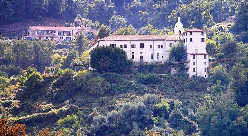
St Francis Convent
The St. Francis Convent is located in the hamlet of Nesa. It was founded in the year 1451 by the Franciscans. It has four cloisters. The monks were expelled at the Revolution. In the year 1836, it was invested by the missionary congregation of the Oblates of Mary Immaculate founded in Provence by Eugene de Mazenod twenty years earlier. Expelled by the anticlerical laws of the early twentieth century, the fathers returned back in the year 1936. They now provide services to many parishes in the surrounding villages without being a pastor.
Open to the public, the convent lends itself to many spiritual and cultural activities. The convent organizes regularly festivals, meetings, entertainment, but also annual evenings "soup and couscous.
St. Francis Church
The St. Francis Conventual Church is located in Nesa. It contains four works classified as Historical Monuments, the Foundation of Mazenod property:
- Christ on the cross statue, known as Franciscone, sculpture of a high meter in the fifteenth and sixteenth centuries;
- screed (white ornament), embroidered fabric of the eighteenth century;
- furniture sacristy of the year1664;
- tabernacle of the year 1698.
Church Sainte-Marie parish
The parish church is located in the northeast of the city of Vico. It contains 15 paintings, all property of the commune and classified in under the Historical Monuments title:
- framework Monseigneur François Citadella. A native of Vico, he was the Bishop of the Cathedral of Nebbio from the year 1773 to 1775, before being Bishop of Mariana from the year 1775 to 1782 Pictures;
- Christ bearing his cross between the two thieves carrying theirs, the way of the cross on canvas of the eighteenth century Pictures;
- St. Jerome of the seventeenth century Pictures;
- St. Jerome of the seventeenth century Pictures;
- the Holy family of the seventeenth century Pictures;
- Ecce Homo of the seventeenth century Pictures;
- baptism of Christ of the seventeenth century Pictures;
- Annunciation of the seventeenth century Pictures;
- pope Gregory XIII picture frame, and identified Ugo Buoncompagni, undated
- Pentecost painting according to the painter Charles Brown, assumed to be in the seventeenth century;
- painting of saint Francis in prayer (St. Francis of Assisi) of the seventeenth century;
- A picture of The forerunner John the Baptist or the preaching of saint John the Baptist of the seventeenth century;
- Painting of the Virgin between St. Francis of Assisi and Saint Clare of the eighteenth century;
- picture of the birth of St. John the Baptist in the seventeenth century;
- Holy family painting or the presentation of the child Jesus to the old Simeon of the seventeenth century.
Other religious heritages
- Chigliani Chapel, located at the south entrance of the village
- Nesa Chapel, located in the hamlet choir
- Apricciani Chapel, located in the village choir
- Sagone Chapel, located at the Southeast end of the commune
- The Chapel on the road to Saint-Antoine, close to the junction of the D70 and D423 roundabout Road.
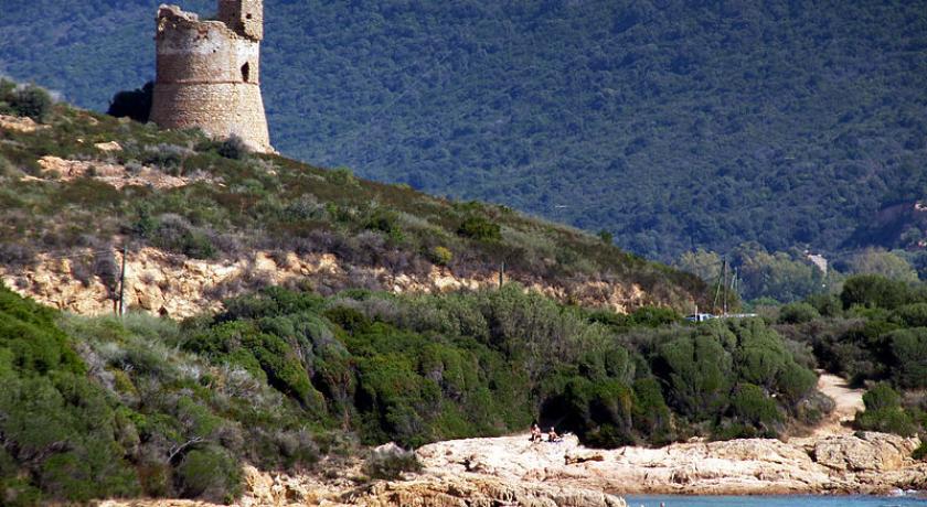
Tour de Sagone
Sagone Tour
The Genoese of Sagone tower was built at the beginning of the seventeenth century, at the same time as the towers of Omigna, Orchino, Cargèse and Capo Rosso. This coastal lookout tower is located to the west of the Cove or Bay of Sagone. it is in a good state of conservation.
On the 12th of April 1763, the Tower of Sagone was dominating Scala di Savona (port of Sagone), guarded by the Genoese to protect the transport of timber from the forest of Aitone, and was latter attacked by the Corsicans. After a first failure, their business later became successful a few days after.
On the 1st of May 1811, an English air force attacked the three French ships embossed at the bottom of the Bay of Sagone. Artillery was installed on the upper platform of the tower and a battery was built at its foot. After less than two hours of fighting, the English salvos have reasons for the French resistance. The Tower suffered no damage during this battle.
The Tower of Sagone was listed under the Historic Monuments title.
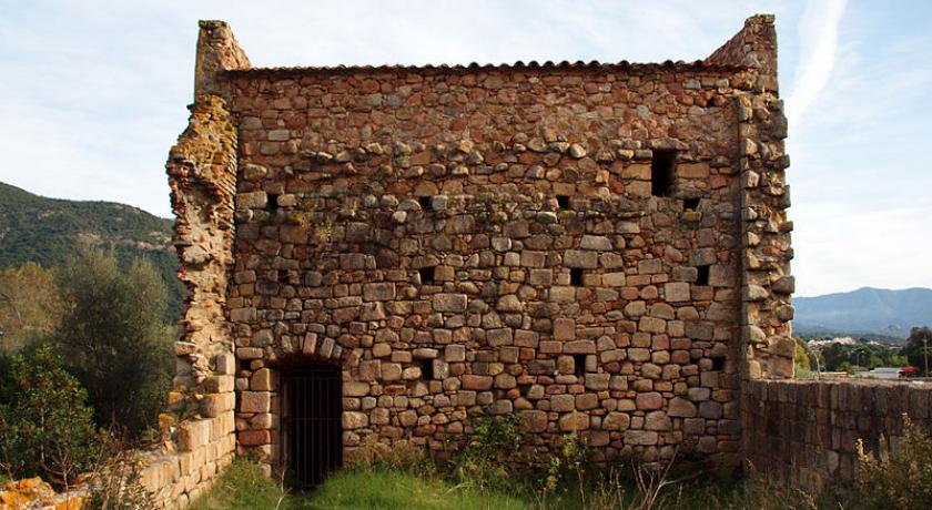
Statue-menhir of Appriciani
The statue-menhir named the ancient Figure of Appriciani, was dated from the Bronze Age. it was found on the field of Mr. Dominico Colonna, at Appriciani, near Sagone. This statue was wrongly recognized by Prosper Mérimée and Henri Aucapitaine as "a Phoenician sarcophagus lid".
The statue was classified as an Historical Monument.
Cultural heritage
- Memorial of monseigneur Casanelli of Istria, former Bishop of Ajaccio. It was erected in the year 1887 on the decision of the City Council of Vico as of November 1886,. Located today at place Casanelli of Istria, it is repeated in the general inventory of the cultural heritage.
- War memorial
Natural heritage
Conservatory of coastal space
The Conservatory of the coastal space has acquired a land of 20 hectares under the (FR1100067) TRIU.
ZNIEFF
Vico was affected by three ZNIEFF of the 2nd generation:
Chestnut oak grove of Renno-Vico
The area covers 2 773 hectares of six average mountains municipalities in the region of Vico. The vegetation, typical climatic conditions, relatively temperate and humid weather is dominated by the abandoned chestnut groves up to 1 100 m of maximum altitude, and lower by the green oak.
Liamone Gorges ahead of the Truggia bridge
The area covers 2 460 hectares of five mid-mountain municipalities, between 40 m to an altitude of 1 196 m. It is a mountainous granitic area which rises to 1 196 m intersected by the meandering Liamone river, forming three distinct massifs: Canapaje and Calcatoghiu in the North, Castaldu in the Center and Castellucciu in the South. The cavesite is very large, weakly frequented by the tourists, but offers remarkable points of view. The different cliffs form a sort of circus to the East of the village of Muna.
Afforestation of the Sagone plain and Sandy terraces
Vico and Balogna are affected by this ZNIEFF which covers 342 ha. The area runs along the Sagone River from its mouth up to 10 km up its course to the North/East. It corresponds to a vast alluvial plain, which offers a wide range of faunistic and ecological interests very important.
Geology and relief
Vico is a mountain located in “there by mounts", the granite part of the island. The site presents mountains emerging from a thick, green vegetation composed of chestnut trees, Oaks, pines laricio and a high maquis. It has one on the Sagone marine.
Its territory consists of three parts:
- The northeast part to the municipality is an opened bowl to the East on the Liamone river and its tributary stream of Catena. it is surrounded to the West by the ridge of Tragunatu continuing to the punta di Miglia (821 m), to the North by the ridge line oriented from the punta di Miglia on the punta di the Arinella (1 001 m, ' on horseback' on Renno and Letia), and on the South by a ridge line starting from the bed of the Liamone and up to the punta di Cuma (904 m); The ridge line that connects the crest of Tragunatu to the punta di Cuma includes the Sant'Antonio pass, crossed by the D70 road that's junction with the D56 and D23 roads. This part contains the ancient inhabited places of Vico, Chigliani and Nesa.
- The central part is 2/5 of the territory. It is a zone of medium mountains cut in half by the Sagone river. In the Eastern sector, lower, lies the ancient village of Appriciani dominating the plain of the Sagone river. There are the ancient baths of Caldanelle. The western sector is dominated by a ridge line from the capu di Radi (806 m), the capu a a Cuma (755 m), punta Tramuntaghia (668 m), punta di Pigno (562 m), the Capu a e Mure (487 m) and ending at the sea at the punta di Trio.
- The western part, which also represents the 2/5 of the territory, extends to the western coast of the island, from a ridge line to the North is on which lies its culmen (1 120 m above sea level). This part represents the end of a high mountainous ridge articulated on the ridge of the island at the tip of Cricche (2 053 m) and ends on the coast at the Capu a u Bellu, through Capu di Calazzu (1 131 m, Summit "on horseback" on Vico, Balogna and Marignana.) which in this part creates two main valleys, those of the Bubia stream and the Sagone river.
The coastal frontage
It is approximately 3.2 km of coast in the Gulf of Sagone, from the stream mouth of Bubia to the North of Triu Funtanella, to the South end of the beach of Sagone. It includes the punta di Trio, the capu a u Bellu, a maritime point closing the Sagone Cove to the West (the other end being Capu San Ghiseppu to the East) as well as the remarkable beach of Sagone.
Territorial boundaries
- In the North, demarcation, a ridge line, starts near Capu di Calazzu (1 131 m) to the West, and heads East towards Punta di Arinella (1 001 m), Summit "on horseback" Coggia and Renno.
- It passes through pointe Calazzu (907 m), Capu di Radi (806 m), declined by the Bocca a Penta until the bed of the stream of Juane Rangu (tributary of the Sagone river), goes back to its course then that of the Creek of Alinu, climbs on the ridge of Tragunetu up to the Punta di Miglia (821 m), passes through the junction D70 and D156 roads and follow the latter until the bridge of Catena.
- To the East from the bridge of Catena, the demarcation follows the course of the Catena stream until its confluence with the Liamone, down the River to the confluence of the right bank of a small stream without name. This stream serves as a municipality boundary to Vico and Coggia, up to the Punta di Cuma (904 m) where it is began. The demarcation becomes almost rectilinear to the Punta di Maschio (804 m), where it follows a new ridge line passing through the Punta di a Saltelle (852 m) and a 920 meters’ bollard. It then descends towards the bridge of Travarce of the D70 road, via Punta Tippone (451 m) and follow the course of a stream flowing into the Sagone river. Finally, to the sea, the D70 Road between Vico of Coggia.
- In the South, lies the maritime façade that starts at the mouth of the Bubia stream to the North and ends at the eastern end of the beach of Sagone to the South.
- Westward, the mouth of the Bubia stream, parting with Cargèse is materialized by Bubia stream, its course up to the waterfall on Cargèse, Marignana, and Vico. From the waterfall, the demarcation follows a ridge climbing up to Capu di Calazzu.
Transport
There is no railway line in the region of Vico. The nearest station is in Sarrola-Carcopino on the Bastia line to Ajaccio and is about 47 km. it is closer to the port and the airport of Ajaccio. There are three artisans-taxis in Sagone as well as several boats for sea trip departing from the small port of Sagone to visit the natural Reserve of Scandola Girolata and the Gulf of Ajaccio.
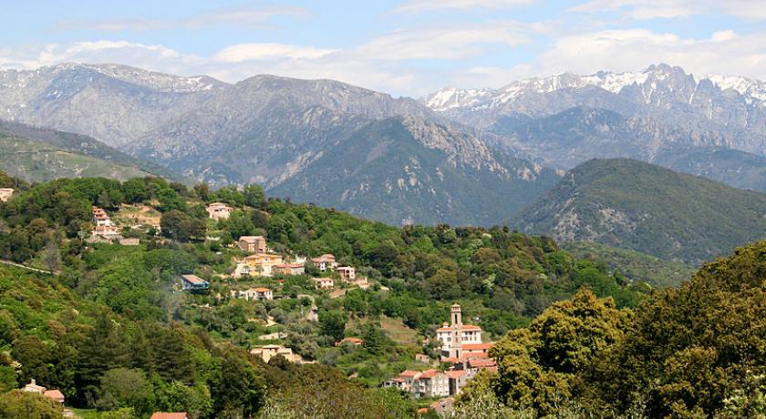
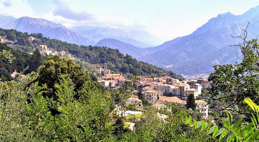
Vico
Vico is a large medieval town located in a small Valley, with remarkable carved granite stone houses, tiered on the wooded slopes of the ridge of Tragunatu, of which the culmen is the tip of Tragunatu 768 m. the small city spreads in a mountain landscape, dominated to the East by the high ridge of the Monte Rotondo massif (Cimatella, Punta alle door and Maniccia).
From the year 1569 to 1625, Vico was a diocese, the residence of the Bishops of Sagone who fled the coast loot by the Berbery. In the year 1625 the Bishop Sebastiano Albani took refuge in the Genoese fortress of Calvi.
The Pieve District is located on a hillside overlooking the city, was, as its name indicates, the center of the Vico piévanie. Pieve is located about 300 m northeast of the parish church Sainte-Marie.
Chigliani
Chiliani is an ancient medieval village located in the north of the town, 1.5 km (orthodromique distance) northeast of Vico, which has its Chapel. It is crossed by road D 156.
Appriciani
Appriciani (or Appricciani or Apricciani, is an old village formerly named Apretiano.) It is located southwest of Vico, built at an altitude of 456 m. It has a chapel and a cemetery. Appriciani is served by the D56 road making to the North junction with the D 70 Acquatella fountain, and to the South with the 81 D, behind the beach of San Giuseppe (Coggia).
Nesa
Hamlet is located about 700 m south of Vico, and was also a former medieval community. Nexa is mentioned as a settlement around 15207. There is a chapel attached to the small cemetery.
About 500 m to the East, stands the convent of St. Francis, connected to Nesa by the D423 road.
Sagone
Sagone (Saone) is a seaside resort. It was once an important city of Corsica. For centuries Sagone has been the headquarter of the eponymous diocese, one of the six dioceses of the island. The diocese of Sagone was established in the eighth century as a result of the transfer of the bishopric of Tanata. The diocese was transferred to Calvi from the sixteenth century to 1790. Sagone was ravaged several times by the Berbers, and deserted by the Bishop who went to take refuge in Vico (from the year 1569 to 1625) before winning the Genoese fortress of Calvi. there are still the remaining of the old cathedral Sant'Appiano and a chapel.
Located on the seafront of the commune of Vico, at the bottom of the Gulf and at the mouth of the eponymous River, Sagone has a natural setting today highly appreciated. Small port dominated by the remarkable Tower of Sagone, beautiful and long sandy beach are its main assets, major attractions for tourism. Also, the site is growing quickly on the waterfront with new construction of houses and businesses. An annex of the town hall was established there. There is a chapel.
source https://fr.wikipedia.org/wiki/Vico_(Corse-du-Sud)
Address
Vico
Frankrijk
Lat: 42.166568756 - Lng: 8.797796249

