
Description
Takamaka is a Valley located in the East of the island of Réunion, in the municipal territory of St. Benedict.
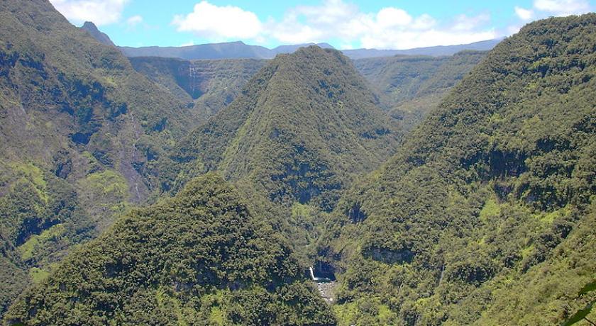
Takamaka Valley is entirely located in the central part of the municipality of Saint-Benoit. It marks the natural boundary of the forest of Bébour West by creating a fracture in the continuity of the plateau of this former circus. It is bounded to the South by the dry hillside and the rampart of Patience Island and on the south-east and east by the ridge of the Grand Étang and the ramparts of the Crater Massif. Its north-east-north boundary is a little more fuzzy but can be defined starting from the confluence of the Fly ravine, going up to the Piton Papangue range and following the ridge to the Deux Mamelles, the Marseille Camp and the ridge between the Mazerin Arm and the Roches River. The Northwest limit through the bed of the arm Patience first before joining the platform of the swallows. The northwestern limit passes first by the Patience Arm bed before reaching the Swallows platform. The northern division takes into account the sub-catchment basins and the watershed of the tributaries of the Marsouins River and the relief layout, favoring the monitoring of the ridges.
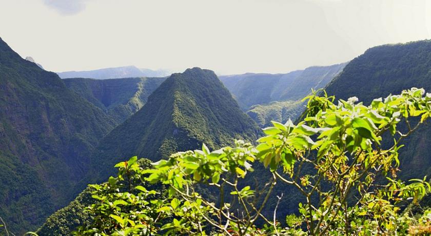
The Valley is especially marked in the Center by the piton Dorseuil which rises to 729 meters above sea level and its long Ridge joining the plateau of Bébour and Deux Mamelles to the North at an altitude of 1332 meter. It is crossed by the river of Marsouins, it was she who dug its flanks to produce the current collection, the Valley includes all of the middle course of the river. There are two main tributaries: Patience arm on which is located a capture and which has its source near the wall of the Mazerin, its point of confluence with the river of Marsouins is located in front of the Ginger waterfall. And the Cabot Arm whose course, separated by the peak of the Dorseuil peak, is almost parallel to that of the Rivière des Porcouins. It has dug all the southern part of the valley and takes its source near the rampart of Coteau Sec. The Takamaka Valley marks the beginning of the perennial part of the Marsouins River, in fact the upper course of the river crosses the Bébour plateau where virtually no perennial resurgence is imaginable, so it is dry on this part. Shortly after the first broken appear the first emergences, the flow is then multiplied thanks to many sources, letting out the water in the aquifer of the plateau of Bébour. Out of the Valley for the Takamaka, the Marsouins River practically reached its maximum flow.
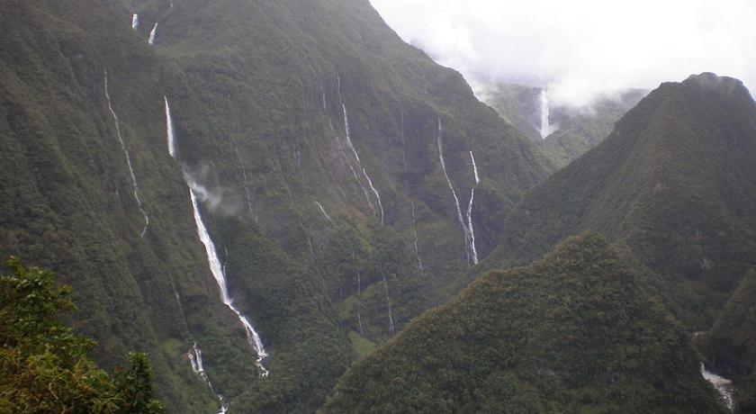
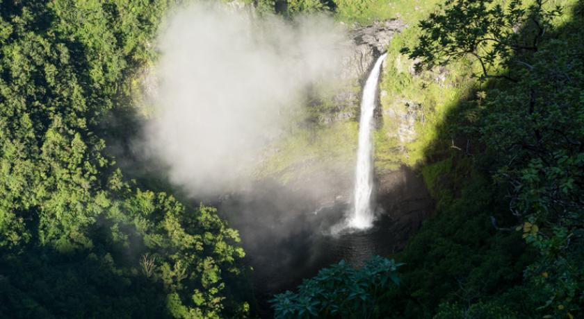
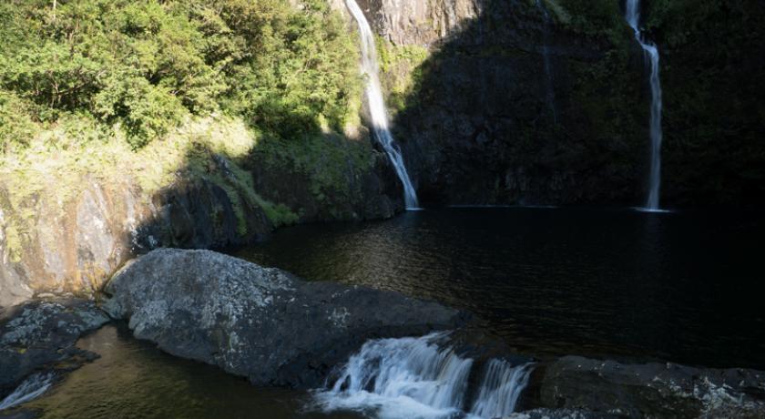
Marsouins River side, from the confluence point with the Cabot arm, the river became more collected, observed the succession of sometimes high waterfalls of 50 meters, of which the most important are the Arc-en-Ciel cascade waterfall overhang, Ginger cascading, the waterfall upstream of the dam, the cascade cemetery, the waterfall of the hole, the cascade lemon and the Mini hole iron.
Geology
Takamaka Valley is dug into the old lavas of the piton of snow. It s the result of regressive erosion in ancient phases II, III and IV. It once represented the outlet of paléocirque Bébour dug in ancient basalt flows in Phase II and olivine mainly in lavas differentiated hawaiite type and phase III mugearites. After the installation of caldera II (at the origin of the ramparts of the Mazerin), circus Bébour will widen and assert itself. This circus is filled after filling the Caldeira II, corresponding to the second series of differentiated lavas. The volume of lava emitted are then quite small but enough to fill the depressions Bélouve tray and plain Porpoises until the present confluence of Cabot arm with (filling pyroclastic and lava) Marsouins River. The digging of the current Valley was made between −70 ka and today.
Hydroelectric developments
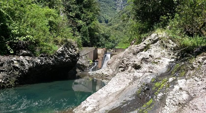
The Valley is home to two hydroelectric dams: Takamaka dam I also called dam ginger and Takamaka II dam also known as the swallow’s dam. There are also several small catchments for supplementation, the main capture of the Cabot arm and arm Patience. The factory is located at 316 meters deep in the middle of a small basalt massif at the foot of the natural platform of PK 16 (796 m) and the col des Songes (783 m).
History
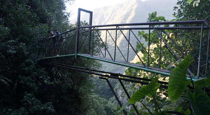
The project to use the water of the river of porpoises to produce energy which dates back to the 1920s, the valley was then one of the most preserved places of the meeting, known to some foresters and inhabitants of the plain of Palmistes, no road led to it, and it was necessary to take the difficult and long paths traversing the forest of Bébour or that of the Cabot Arm, pacing the plateau of Îlet Patience to the thermal springs of the same name. The reunion hydroelectric company launched the studies and works began in 1928. The difficulties encountered were then enormous in a zone as abrupt and wild. The path used for the work started from the Plain Palmistes, reached the neck of Bébour and joined the current platform of the Swallows crossing the Bébour forest. He then dived to the islet at Bananes, taking a kidney. The difficult and vertiginous descent was then equipped with modest wooden ladders (48 in all) and all the equipment was lowered on the back of a man. From the islet at Bananes a path was drawn towards the neck of Songes. At the same time, the Grand Fond road is being built to reach the Col des Songes and the current Pk 16, and you can now reach Bananes from Saint-Benoît. However, the company had to dissolve due to a financial crash. The project remained forgotten until 1954, when a new study was launched in parallel with the Langevin hydroelectric project, but it was still ten years before the work began. First, a path was created to access the small massif (called at that time the nipple) located below the Pk16 platform (the current road terminus). After the preliminary development of the site, a cable car was built to bring down construction on the site materials. A trench is dug on the slope to allow the implementation of an inclined plane of 347 meters in length. Working conditions were extremely difficult at that time and several workers lost their lives. They were housed in barracks in sheet metal, forming small camps, cliff side during the construction of the inclined plane, or on a small plateau located not far from the fall of the Gaulettes for the construction of the restitution tunnel for example.
At the same time the construction of the main water intake is in process. An arch dam threshold spilling from 44 meters in length and 15 meters high was built immediately upstream of the ginger waterfall at 505 meters above sea level. The materials are transported on site via a cable car. A tunnel 1190 meters long and 2 meters in diameter is pierced with explosives and allows water to be transported to the plant. A tower was built above the 316-meter deep hole and houses a lift and elevator. The water coming from the tunnel reaches the equilibrium chamber before beginning its final descent into a vertical drop well 300 meters long and 1.61 meters wide. The water was pressurized through the progressive narrowing of this well (which reaches then 80 cm in diameter). The conduit below divides into 2 branches to feed the two turbines at that time. The water is then returned to the River at the end of a gallery 400 meters long opening a hundred meters after the confluence of the Petit Bras Store with the Rivière des Porpoises.
In 1984, as a result of the increase in the island's electrical demand, the construction of a new hydroelectric dam was launched. A 26-meter high spillway dam is built at the height of the Swallows' cave at an altitude of 852 meters between two 1,800 meters high plant walls. The reservoir is capable of holding 126 000 m3 of water and becomes the biggest hydroelectric dam on the island of Réunion. The Materials are transported on site by helicopter and by a cable car built on the platform of the swallows to Bébour, a track allows access to the forest road Bébour / Bélouve. A fully armored supply tunnel 4,500 meters long is dug using a tunnel boring machine across the massif. It carries water from the dam to the newly excavated Takamaka II plant in the nipple near the Takamaka I power station. The water is then returned to the river through the same return tunnel. The creation of this new dam caused a drop in flow at the Ginger dam, so it was necessary to find a solution. An 865-meter-long tunnel was dug in the Dorseuil peak to divert part of the Cabot River flow to the Rivière des Marsouins, the water was restored between the Trou and Cimetière waterfalls, and its construction required a cable car connecting Pk 16 to the artificial platform created for the occasion at the entrance of the tunnel. Several other small tunnels are also drilled to carry water from one site to another where to join the factories, a small dam on Bras Patience is built. The plant was commissioned in 1989.
Hiking
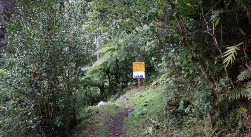
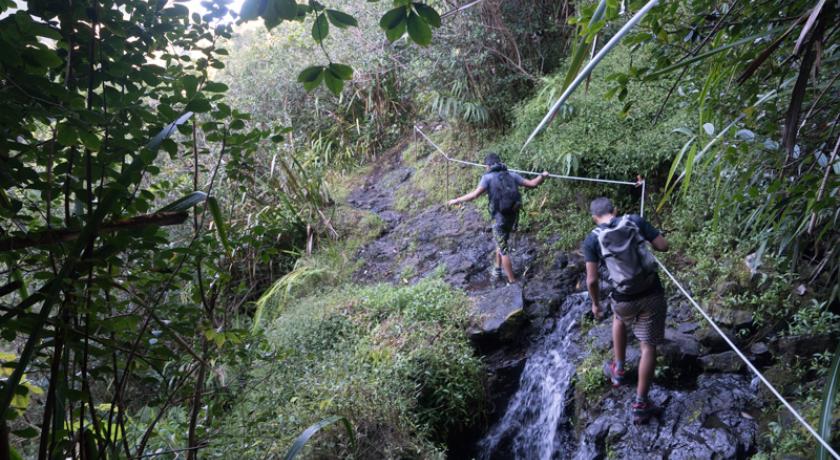
The Takamaka Valley is covered by many hiking trails. The main trail leads to Bébour Forest after four to five hours of effort along the trail of the first attempt to build a hydroelectric dam on the Rivière des Porcouins. The sometimes-dizzying trail meanders along the rampart, passing over the magnificent bridge of Bras Patience and the 24 ladders of the rise of the Îlet à Bananes. Several other trails make it possible to reach the various dams and catchments built in the region, such as Bras Patience, Takamaka I, Takamaka II or Bras Cabot.
Canyoning
Takamaka est un haut lieu du canyoning réunionnais et même mondial. La vallée encaissée est le lieu idéal pour la pratique de ce sport extrême. Dans les années 90 on assiste à l'avènement du canyoning dans l'île, en l'espace de 10 ans la grande majorité des cours d'eau est visitée. Un des pionniers dans cette discipline est Pascal Colas, ce guide de haute montagne est à l'origine de l'importation des loisirs sur corde à la Réunion et a participé activement à l'ouverture des principaux canyons de l'île. Dans la vallée, le premier canyon à être ouvert fut celui de Takamaka I (du pont de la route forestière de Bébour/Bélouve au barrage des Hirondelles) au bout d'une expédition de 3 jours (23, 24 et 25 novembre 1990) composée de Marianne Chamel, André Bonzo, Thierry et Pascal Colas, c'est sur ce canyon que se trouve le mythique Mini Trou de fer. Cinq mois plus tard c'est le second tronçon de la rivière qui est ouvert entre les deux barrages, c'est le canyon de Takamaka II. L'expédition composée de Patrick Landabourou, Didier Rouaux, Christophe Lecef, Marcel Faure et Pascal Colas se déroula sur trois jours du 3 au 5 avril 1991 et permit de taquiner les fameuses cascades Citron, du Trou et Cimetière. Le dernier tronçon de la rivière des Marsouins est ouvert en deux phases le 21 et 25 décembre 1991 par Pascale Veyrier, Suzelle Grondin, Éric Verhoest, Jean-Pierre Pilou, Yves Sadecki et Pascal Colas. C'est le dernier de la trilogie sur le cours principal de la rivière.
Canyoning
Takamaka is a high place of canyoning Réunion and even global. The Valley is the ideal place for the practice of this extreme sport. In the 1990s we can see the advent of canyoning on the island, in the space of 10 years the vast majority of rivers was visited. One of the pioneers in this discipline is Pascal Colas, this mountain guide is at the origin of the import of rope recreation in Reunion Island and actively participated in the opening of the main canyons of the island. In the Valley, the first canyon to be opened was that of Takamaka I (from the Bébour / Bélouve forest road bridge to Les Hirondelles dam) at the end of a 3-day expedition (23, 24 and 25 November 1990) composed of Marianne Chamel, André Bonzo, Thierry and Pascal Colas, it is on this canyon that is the mythical Mini Hole Iron. Five months later it's the second stretch of the river which is open between the two dams, is the canyon of Takamaka II. The expedition made up of Patrick Landabourou, Didier Rouaux, Christophe Lecef, Marcel Faure and Pascal Colas took place over three days from 3 to 5 April 1991 and allowed to tease the famous waterfalls of lemon, of the hole and cemetery. The last section of the Rivière des Marsouins was opened in two phases on 21 and 25 December 1991 by Pascale Veyrier, Suzelle Grondin, Eric Verhoest, Jean-Pierre Pilou, Yves Sadecki and Pascal Colas. This is the last of the trilogy on the main course of the river.
It then crosses the ginger, overhang and Rainbow waterfalls. In the upper part of the Valley, we're interested in the dizzying broken arm Cabot and Bras song. An expedition was launched on the 10th, 11th and 12th of April 1991 to open the Cabot I arms, it consists of Eline Bonardel, Jean-Luc Chéron, Frantz Limier, Christophe Lecerf, Philippe Kaufman, Marcel Faure and Pascal Colas. In the aftermath, 4 months later, you realize the second section of the arm Cabot (canyon of the arm Cabot II) between the stop and the confluence with the river Marsouins. The expedition composed of Viviane Kaufman, Didier Rouaux, Marcel Faure, Patrick Landabourou, Christophe Lecerf, Jean Jacques Gautier and Pascal Colas runs from August 6 to 8, 1991. The year 1992 was also prolific with the opening of three canyons: the song arms on 18 and 19 may by Hervé Brochart, Antoine Florin and Pascal Colas, the mythical arms store with a 4 days expedition from 19 to 23 October composed of Hervé Douris, Antoine Florin Jean-Manuel Prudhomme and Pascal Colas. This very wild canyon was previously covered in 3 to 4 days, the access was made by a trace in the heart of the primary forest of Patience Island, a time now gone by the re-equipment of the canyon in 2001 by Ricaric which allows access in a day. The last of the year will be the Petit Bras Magasin canyon from December 20th to 23rd by Marcel Faure, Dominique Dumesnil, Pierre Labat and Jean-Pierre Chateau. To remain in the upper part, the canyon Sancho is open from 15 to 18 July 1993 by Marcel and Frédéric Faure, Dominique Dumesnil, Gilles Quertier, Patrick Leuthy and Vincent Kuhnmunch and in the same month arm Patience of 25-26 by Pascale Veyrier Jean Luc Charles, Hervé Douris and Pascal Colas. Farther in the Valley we find the magnificent canyon of Bras sec (opened in September 1991 by Daniel Brillant, Eric Magnien and Chrstian and Jean-Luc Delpech) running through the ravine of the same name and the canyons of the Great Ravine called Dudu canyon: Dudu superior (opening in the 90s by the team of Marcel Faure) starting on the plateau overlooking the quoted old workers of Pk1 and ending at the foot of the waterfall of the same name, and lower Dudu (opening February 25, 1994, by Marcel Faure, Gamet, Patrick Charles Leuthy, Gilles Quertier, Didier Roumec and Éric Delabre) starting at the bridge and ending at the Rivière des Porcouins.
Other hobbies
Fishing is also a hobby practiced in the Takamaka Valley. The site was raised in the 1940s by the NFB to create a population of rainbow trout. It is not uncommon these days to see a few beautiful specimens swimming peacefully in the clear waters of the Porpoises river. The upstream of the first dam is a very popular place for fishing because of its accessibility, but the bravest will prefer to take the difficult trails of fisherman plunging a few times steep in the rampart to reach some fish ponds.
It is also possible to go kayaking in the lower part of the Valley. A circuit is to reach the Coco islet from the hydroelectric plant, it is accessible only to the most seasoned.
A view on the Valley of Takamaka located more than 800 meters is accessible from the town of St. Benedict by a 15 kilometers long road. Open day, you can see the central part of the Piton des Neiges massif (on the left), as well as the ramparts of the Mafate cirque.
source https://fr.wikipedia.org/wiki/Takamaka_(La_R%C3%A9union)
Address
Takamaka
Réunion
Lat: -21.091264725 - Lng: 55.619949341

